

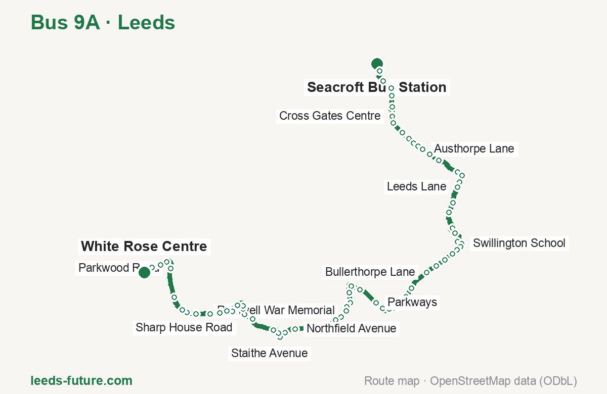
Bus 9A in Leeds links Seacroft Bus Station and White Rose Centre. The route is 23.8 km long with 71 stops, and the official schedule from West Yorkshire Combined Authority (Metro) puts the full trip at about 50 minutes. On a weekday it runs 6 trips in one direction, and 8 on a weekend day.
Route at a glance
| Mode | Bus |
|---|---|
| Route number | 9A |
| City | Leeds |
| Operator | West Yorkshire Combined Authority (Metro) |
| Start → end | Seacroft Bus Station → White Rose Centre |
| End → start | White Rose Centre → Seacroft Bus Station |
| Route length | 23.8 km / 23.9 km in the opposite direction |
| Number of stops | 71 / 65 in the opposite direction |
| Travel time | about 50 minutes |
| Trips per day | 6 on weekdays, 8 on weekends one way |
| Frequency | weekend 118 |
| First / last trip from «Seacroft Bus Station» | 04:30 / 22:30 |
| First / last trip from «White Rose Centre» | 18:30 / 21:30 |
| Fare | 2.50 £ (fare in effect since 30 March 2025) |
| Updated | August 22, 2026 |
Route of Bus 9A
Outbound: Seacroft Bus Station → White Rose Centre
This direction has 71 stops and runs 23.8 km. The route passes Seacroft The Green, Leeds Lane, Oulton Hall, Bradburn Road. Below is the full list with the distance from the first stop.
| No. | Stop | From start | Note |
|---|---|---|---|
| 1 | Seacroft Bus Station | 0.0 km | Terminus |
| 2 | Seacroft The Green | 0.6 km | |
| 3 | Stocks Approach | 1.0 km | |
| 4 | Barwick Road | 1.6 km | |
| 5 | Manston Drive | 1.8 km | |
| 6 | Cross Gates Lane | 2.2 km | |
| 7 | Cross Gates Centre | 2.5 km | |
| 8 | Cross Gates Station | 2.7 km | |
| 9 | Kingswear Parade | 3.1 km | |
| 10 | Baronsmead | 3.4 km | |
| 11 | Skyliner Roundabout | 3.6 km | |
| 12 | Detroit Drive | 3.8 km | |
| 13 | Austhorpe Lane | 4.0 km | |
| 14 | Colton Retail Park | 4.3 km | |
| 15 | Thorpe Park | 4.7 km | |
| 16 | Carrwood Park | 5.4 km | |
| 17 | Selby Road | 5.6 km | |
| 18 | Hillcrest Farm | 5.9 km | |
| 19 | Leeds Lane | 6.1 km | |
| 20 | Hollinthorpe | 6.6 km | |
| 21 | Temple Thorpe Farm | 7.0 km | |
| 22 | Smeaton House Farm | 7.5 km | |
| 23 | Whitecliffe Crescent | 7.7 km | |
| 24 | Smeaton Grove | 8.1 km | |
| 25 | Swillington School | 8.3 km | |
| 26 | Swillington Church | 8.4 km | |
| 27 | Swillington Club | 8.6 km | |
| 28 | Hill Crest | 8.8 km | |
| 29 | Swillington Lane | 9.1 km | |
| 30 | Jinny Moor Lane | 9.4 km | |
| 31 | Bullerthorpe Lane | 9.8 km | |
| 32 | Woodlesford Station | 10.6 km | |
| 33 | Woodlesford Co-op | 10.9 km | |
| 34 | Fleet Lane | 11.3 km | |
| 35 | Calverley Rd Chapel Yard | 11.6 km | |
| 36 | Oulton Hall | 11.9 km | |
| 37 | Parkways | 12.2 km | |
| 38 | Park Lane | 12.8 km | |
| 39 | Cross Avenue | 13.2 km | |
| 40 | Rothwell Cemetery | 13.5 km | |
| 41 | Thorne Grove | 13.8 km | |
| 42 | Park Ln Abraham Hill | 14.1 km | |
| 43 | Rothwell War Memorial | 14.2 km | |
| 44 | Rothwell Library | 14.5 km | |
| 45 | Victoria Avenue | 14.7 km | |
| 46 | Rothwell School | 15.0 km | |
| 47 | Stainton Lane | 15.2 km | |
| 48 | Rhubarb Farm | 15.5 km | |
| 49 | Northfield Avenue | 16.1 km | |
| 50 | Copley Lane | 16.4 km | |
| 51 | Leadwell Lane Leeds Rd | 16.7 km | |
| 52 | Halfway House | 16.9 km | |
| 53 | Bradburn Road | 17.1 km | |
| 54 | Sharp House | 18.0 km | |
| 55 | Sharp House Road | 18.3 km | |
| 56 | Sharp Lane School | 18.5 km | |
| 57 | Throstle Road North | 18.6 km | |
| 58 | Lanshaw Crescent | 18.9 km | |
| 59 | Middleton Centre C | 19.4 km | |
| 60 | Middleton Centre A | 19.6 km | |
| 61 | Staithe Avenue | 19.9 km | |
| 62 | Lingwell Road | 20.2 km | |
| 63 | Middleton Park Circus C | 20.6 km | |
| 64 | Middleton Park Road | 20.9 km | |
| 65 | Middleton Water Tower | 21.1 km | |
| 66 | Bodmin Road | 21.6 km | |
| 67 | Parkwood Road | 22.6 km | |
| 68 | Waincliffe Drive | 22.9 km | |
| 69 | Ring Road Beeston | 23.2 km | |
| 70 | Thirlmere Gardens | 23.5 km | |
| 71 | White Rose Centre | 23.8 km | Terminus |
Inbound: White Rose Centre → Seacroft Bus Station
This direction has 65 stops and runs 23.9 km. The route passes Thirlmere Gardens, Sharp House, Park Lane, Smeaton House Farm. Below is the full list with the distance from the first stop.
| No. | Stop | From start | Note |
|---|---|---|---|
| 1 | White Rose Centre | 0.0 km | Terminus |
| 2 | Thirlmere Gardens | 0.6 km | |
| 3 | Waincliffe Drive | 0.9 km | |
| 4 | Tommy Wass Junction | 1.2 km | |
| 5 | Bodmin Road | 2.5 km | |
| 6 | Middleton Water Tower | 3.0 km | |
| 7 | Middleton Park Road | 3.1 km | |
| 8 | Middleton Park Circus A | 3.5 km | |
| 9 | Lingwell Road | 3.8 km | |
| 10 | Staithe Avenue | 4.1 km | |
| 11 | Middleton Centre B | 4.4 km | |
| 12 | Middleton Centre D | 4.9 km | |
| 13 | Lanshaw Crescent | 5.2 km | |
| 14 | Throstle Road North | 5.7 km | |
| 15 | Sharp Lane School | 5.8 km | |
| 16 | Sharp House Road | 6.0 km | |
| 17 | Sharp House | 6.3 km | |
| 18 | Bradburn Road | 7.2 km | |
| 19 | Halfway House | 7.5 km | |
| 20 | Copley Lane | 7.8 km | |
| 21 | Northfield Avenue | 8.2 km | |
| 22 | Rhubarb Farm | 8.7 km | |
| 23 | Stainton Lane | 9.1 km | |
| 24 | Rothwell School | 9.3 km | |
| 25 | Marsh Street Library | 9.7 km | |
| 26 | Gillett Lane | 9.9 km | |
| 27 | Park Lane | 10.2 km | |
| 28 | Thorne Grove | 10.5 km | |
| 29 | Rothwell Cemetery | 10.8 km | |
| 30 | Styebank Lane Leeds Rd | 11.0 km | |
| 31 | Cross Avenue | 11.1 km | |
| 32 | Park Lane | 11.6 km | |
| 33 | Parkways | 12.1 km | |
| 34 | Calverley Road | 12.7 km | |
| 35 | Fleet Lane | 12.9 km | |
| 36 | Woodlesford Co-op | 13.4 km | |
| 37 | Woodlesford Station | 13.7 km | |
| 38 | Bullerthorpe Lane | 14.4 km | |
| 39 | Jinny Moor Lane | 14.8 km | |
| 40 | Swillington Lane | 15.2 km | |
| 41 | Hill Crest | 15.4 km | |
| 42 | Swillington Club | 15.6 km | |
| 43 | Swillington Church | 15.8 km | |
| 44 | Swillington School | 15.9 km | |
| 45 | Smeaton Grove | 16.1 km | |
| 46 | Whitecliffe Crescent | 16.5 km | |
| 47 | Smeaton House Farm | 16.9 km | |
| 48 | Temple Thorpe Farm | 17.3 km | |
| 49 | Hollinthorpe | 17.6 km | |
| 50 | Leeds Lane | 18.1 km | |
| 51 | Hillcrest Farm | 18.3 km | |
| 52 | Carrwood Park | 18.7 km | |
| 53 | Thorpe Park | 19.5 km | |
| 54 | Colton Retail Park | 19.9 km | |
| 55 | Austhorpe Lane | 20.1 km | |
| 56 | Detroit Drive | 20.4 km | |
| 57 | Skyliner Roundabout | 20.7 km | |
| 58 | Kingswear Parade | 21.2 km | |
| 59 | Cross Gates Station | 21.5 km | |
| 60 | Cross Gates Centre | 21.8 km | |
| 61 | Cross Gates Lane | 22.2 km | |
| 62 | Manston Drive | 22.5 km | |
| 63 | Stocks Approach | 23.2 km | |
| 64 | Seacroft The Green | 23.6 km | |
| 65 | Seacroft Bus Station | 23.9 km | Terminus |
Schedule and frequency
According to the official schedule from West Yorkshire Combined Authority (Metro), the route runs 6 trips in one direction on a weekday, and 8 on a weekend day.
| Direction | Weekdays | Weekends and holidays |
|---|---|---|
| From «Seacroft Bus Station» | 04:30 — 22:30 | 10:29 — 16:30 |
| From «White Rose Centre» | 18:30 — 21:30 | 09:30 — 17:31 |
Frequency calculated from the departure table: on weekends every 118 minutes.
Fare and payment
A single ride costs 2.50 £ — fare in effect since 30 March 2025. The same fare applies to buses in West Yorkshire.
No single bus journey in West Yorkshire costs more than £2.50 — this is the Mayor’s Fare cap, so the actual price charged by an operator can be lower. A DaySaver is £6.00, and the multi-operator MCard covers buses across the county.
Frequently asked questions
How much does a ride on bus 9A cost?
2.50 £ for a single ride — fare in effect since 30 March 2025.
When do the first and last trips run?
From Seacroft Bus Station the first is at 04:30 and the last at 22:30. From White Rose Centre they are 18:30 and 21:30.
How long does the trip from Seacroft Bus Station to White Rose Centre take?
About 50 minutes end to end — the median of full trips in the official schedule.
How many stops does the route have?
71 outbound and 65 inbound according to the official GTFS feed. The two lists do not match exactly.
Does bus 9A run on weekends?
Yes. On weekends and holidays there are 8 trips in one direction, running from Seacroft Bus Station between 10:29 and 16:30.
Every route number with its termini, operating hours and travel time is collected in the Leeds buses overview.
Data current as of August 22, 2026. Schedule and termini — West Yorkshire Combined Authority (Metro). Fares — West Yorkshire Combined Authority. Stop list, schedule and route geometry come from the official GTFS feed (Bus Open Data Service (BODS)).