

Bus 49 in Leeds links Bramley Centre Bus Station and Monkswood Gate. The route is 17.2 km long with 55 stops, and the official schedule from West Yorkshire Combined Authority (Metro) puts the full trip at about 75 minutes. On a weekday it runs 57 trips in one direction, and 78 on a weekend day.
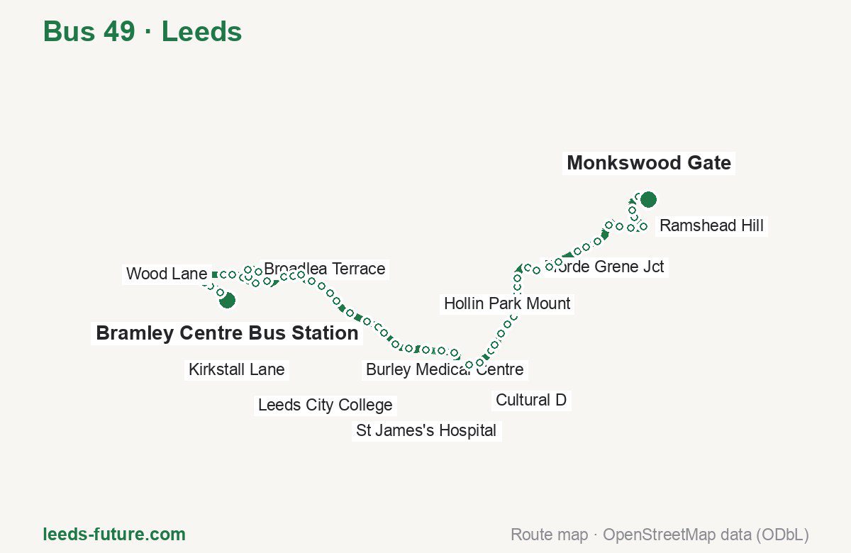
Route at a glance
| Mode | Bus |
|---|---|
| Route number | 49 |
| City | Leeds |
| Operator | West Yorkshire Combined Authority (Metro) |
| Start → end | Bramley Centre Bus Station → Monkswood Gate |
| End → start | Monkswood Gate → Bramley Centre Bus Station |
| Route length | 17.2 km / 17.1 km in the opposite direction |
| Number of stops | 55 / 52 in the opposite direction |
| Travel time | about 75 minutes |
| Trips per day | 57 on weekdays, 78 on weekends one way |
| Frequency | peak 14–22 · midday 12–18 · weekend 12–39 |
| First / last trip from «Bramley Centre Bus Station» | 05:10 / 23:31 |
| First / last trip from «Monkswood Gate» | 04:49 / 23:11 |
| Fare | 2.50 £ (fare in effect since 30 March 2025) |
| Updated | August 22, 2026 |
Route of Bus 49
Outbound: Bramley Centre Bus Station → Monkswood Gate
This direction has 55 stops and runs 17.2 km. The route passes Waterloo Lane, Kirkstall Leisure Centre, Headrow J, Fforde Grene Jct. Below is the full list with the distance from the first stop.
| No. | Stop | From start | Note |
|---|---|---|---|
| 1 | Bramley Centre Bus Station | 0.0 km | Terminus |
| 2 | Waterloo Lane | 0.3 km | |
| 3 | Westover Road | 0.6 km | |
| 4 | Bramley Park | 0.8 km | |
| 5 | Newlay Lane | 0.9 km | |
| 6 | Wood Lane | 1.4 km | |
| 7 | Wellington Grove | 1.6 km | |
| 8 | Lincroft Crescent | 1.9 km | |
| 9 | Broadlea Place | 2.3 km | |
| 10 | Broadlea Crescent | 2.5 km | |
| 11 | Broadlea Terrace | 2.7 km | |
| 12 | Broadlea Close | 3.0 km | |
| 13 | Broadlea Mount | 3.3 km | |
| 14 | Kirkstall Bridge Shopping Park | 3.9 km | |
| 15 | Kirkstall Leisure Centre | 4.1 km | |
| 16 | Kirkstall Lane | 4.3 km | |
| 17 | Eden Road | 4.7 km | |
| 18 | Burley Hill Drive | 4.9 km | |
| 19 | Talbot View | 5.2 km | |
| 20 | St Michael’s Lane | 5.5 km | |
| 21 | Burley Medical Centre | 5.9 km | |
| 22 | Cardigan Road | 6.4 km | |
| 23 | Woodsley Road | 6.7 km | |
| 24 | Rosebank School | 6.9 km | |
| 25 | St Andrews Street | 7.3 km | |
| 26 | Leeds City College | 7.7 km | |
| 27 | Civic N | 8.1 km | |
| 28 | Headrow J | 8.5 km | |
| 29 | Headrow G | 8.8 km | |
| 30 | Cultural C | 9.4 km | |
| 31 | Cultural D | 9.7 km | |
| 32 | Burmantofts Street | 10.2 km | |
| 33 | Nippet Lane | 10.3 km | |
| 34 | Lincoln Green Road | 10.6 km | |
| 35 | Bexley Wing | 10.9 km | |
| 36 | St James’s Hospital | 11.2 km | |
| 37 | Ashley Road | 11.4 km | |
| 38 | Conway View | 11.8 km | |
| 39 | Harehills Place | 12.0 km | |
| 40 | Harehills Nice View | 12.2 km | |
| 41 | Fforde Grene Jct | 12.6 km | |
| 42 | Easterly Grove | 12.8 km | |
| 43 | Arlington Road | 13.2 km | |
| 44 | Hetton Road | 13.4 km | |
| 45 | Oakwood McDonalds | 14.0 km | |
| 46 | Hollin Park Mount | 14.2 km | |
| 47 | Dib Lane | 14.5 km | |
| 48 | Boggart Hill Drive | 15.1 km | |
| 49 | Boggart Hill Road | 15.3 km | |
| 50 | Boggart Hill Cres | 15.6 km | |
| 51 | Ramshead Hill | 16.0 km | |
| 52 | Barncroft Rise | 16.3 km | |
| 53 | Barncroft Drive | 16.5 km | |
| 54 | Monkswood Hill | 16.9 km | |
| 55 | Monkswood Gate | 17.2 km | Terminus |
Inbound: Monkswood Gate → Bramley Centre Bus Station
This direction has 52 stops and runs 17.1 km. The route passes Monkswood Hill, Easterly Grove, Civic P, Kirkstall Lane. Below is the full list with the distance from the first stop.
| No. | Stop | From start | Note |
|---|---|---|---|
| 1 | Monkswood Gate | 0.0 km | Terminus |
| 2 | Monkswood Hill | 0.4 km | |
| 3 | Barncroft Drive | 0.8 km | |
| 4 | Barncroft Rise | 1.0 km | |
| 5 | Ramshead Hill | 1.3 km | |
| 6 | Boggart Hill Cres | 1.6 km | |
| 7 | Boggart Hill Road | 1.9 km | |
| 8 | Boggart Hill Drive | 2.1 km | |
| 9 | Dib Lane | 2.6 km | |
| 10 | Hollin Park Mount | 3.0 km | |
| 11 | Oakwood McDonalds | 3.3 km | |
| 12 | Hetton Road | 3.8 km | |
| 13 | Arlington Road | 4.0 km | |
| 14 | Easterly Grove | 4.4 km | |
| 15 | Harehills Nice View | 5.0 km | |
| 16 | Harehills Place | 5.2 km | |
| 17 | Conway View | 5.5 km | |
| 18 | Ashley Road | 5.8 km | |
| 19 | St James’s Hospital | 6.2 km | |
| 20 | Bexley Wing | 6.4 km | |
| 21 | Lincoln Green Road | 6.6 km | |
| 22 | Nippet Lane | 6.9 km | |
| 23 | Cultural E | 7.5 km | |
| 24 | Victoria G | 8.1 km | |
| 25 | Headrow C | 8.4 km | |
| 26 | Civic P | 8.8 km | |
| 27 | Civic O | 8.9 km | |
| 28 | Leeds City College | 9.4 km | |
| 29 | St Andrews Street | 9.8 km | |
| 30 | Rosebank School | 10.1 km | |
| 31 | Woodsley Road | 10.5 km | |
| 32 | Cardigan Road | 10.8 km | |
| 33 | Burley Medical Ctr | 11.1 km | |
| 34 | St Michael’s Lane | 11.6 km | |
| 35 | Talbot View | 11.8 km | |
| 36 | Burley Hill Drive | 12.2 km | |
| 37 | Eden Road | 12.4 km | |
| 38 | Kirkstall Lane | 12.8 km | |
| 39 | Kirkstall Morrisons | 13.1 km | |
| 40 | Kirkstall Bridge Shopping Park | 13.4 km | |
| 41 | Broadlea Mount | 13.9 km | |
| 42 | Broadlea Close | 14.2 km | |
| 43 | Broadlea Terrace | 14.5 km | |
| 44 | Broadlea Crescent | 14.7 km | |
| 45 | Broadlea Place | 14.9 km | |
| 46 | Lincroft Crescent | 15.2 km | |
| 47 | Wellington Grove | 15.6 km | |
| 48 | Wood Lane | 15.9 km | |
| 49 | Bramley Park | 16.4 km | |
| 50 | Westover Road | 16.6 km | |
| 51 | Waterloo Lane | 16.9 km | |
| 52 | Bramley Centre Bus Station | 17.1 km | Terminus |
Schedule and frequency
According to the official schedule from West Yorkshire Combined Authority (Metro), the route runs 57 trips in one direction on a weekday, and 78 on a weekend day.
| Direction | Weekdays | Weekends and holidays |
|---|---|---|
| From «Bramley Centre Bus Station» | 05:10 — 23:31 | 06:34 — 22:41 |
| From «Monkswood Gate» | 04:49 — 23:11 | 07:36 — 22:56 |
Frequency calculated from the departure table: in the morning peak buses run every 14–22 minutes, most often every 16; midday every 12–18 minutes; in the afternoon peak every 12–28; on weekends every 12–39 minutes.
Fare and payment
A single ride costs 2.50 £ — fare in effect since 30 March 2025. The same fare applies to buses in West Yorkshire.
No single bus journey in West Yorkshire costs more than £2.50 — this is the Mayor’s Fare cap, so the actual price charged by an operator can be lower. A DaySaver is £6.00, and the multi-operator MCard covers buses across the county.
Frequently asked questions
How much does a ride on bus 49 cost?
2.50 £ for a single ride — fare in effect since 30 March 2025.
When do the first and last trips run?
From Bramley Centre Bus Station the first is at 05:10 and the last at 23:31. From Monkswood Gate they are 04:49 and 23:11.
How long does the trip from Bramley Centre Bus Station to Monkswood Gate take?
About 75 minutes end to end — the median of full trips in the official schedule.
How many stops does the route have?
55 outbound and 52 inbound according to the official GTFS feed. The two lists do not match exactly.
Does bus 49 run on weekends?
Yes. On weekends and holidays there are 78 trips in one direction, running from Bramley Centre Bus Station between 06:34 and 22:41.
Every route number with its termini, operating hours and travel time is collected in the Leeds buses overview.
Data current as of August 22, 2026. Schedule and termini — West Yorkshire Combined Authority (Metro). Fares — West Yorkshire Combined Authority. Stop list, schedule and route geometry come from the official GTFS feed (Bus Open Data Service (BODS)).